
Main Body
Chapter 5: The Architecture and Cultural Landscape of the Schefield Community
Anna Andrzejewski
Schefield, and more specifically, St. Pius, served as a center for the surrounding community, particularly for the German-Russians who settled farms in the vicinity during the first few decades of the twentieth century. The church brought the community tighter, functioning as an anchor for them in the otherwise unfamiliar and barren land. If what survives today at Schefield is limited largely to the gravestones memorializing the families in the parish, historic buildings on the farms surrounding Schefield help us tell the story of the community and how it changed over time.
This chapter attempts to synthesize the findings of this year’s field school and the evidence we gathered on the seven farms we studied. It considers our findings on the buildings, farmstead layouts, and the relationship between those buildings and the natural landscape alongside textual evidence (maps, census records, and newspapers) and evidence gleaned from interviews. Our analysis draws some conclusions about the farms and farm life while also suggesting avenues for future research.
Our findings in many ways raise more questions than answers. While we know that settlement patterns, for example, are tied to stipulations of the Homestead Act, the particular reasons for why farmers settled as they did remains somewhat of an open-ended question. Related to this is the layout of the farms themselves. A dominant pattern on the farms we observed was the widespread distribution of principal farm buildings on the farmstead – namely the farmhouse and the barn – for which we have not yet been able to explain. Finally, at the level of individual buildings, we arrived at a sense of typology and evolution over time – but how common this evolution was outside of our examples is somewhat unclear. In short, this study validated the need for further investigation of these buildings to tell the history of this fascinating period of successful settlement on the prairie.
Settling the Prairie
One of our research questions asked what compelled Germans from Russia settlers to occupy the land as they did. Part of this related to the choices the settlers made in siting of their farms, but it also related to the specific buildings they constructed – their form as well as their materials. It also related to choices farmers and farm families made over time, specifically the decisions they made about improving their farmsteads. In order to understand these choices, we began thinking at the largest scale – that is, where farms were settled, when, and with what materials. Also important is the relationship of buildings to the natural world, which continues to be inextricably intertwined (witness the wind farms all across the Dakotas).
As noted earlier in this e-book, widespread settlement of Stark County occurred between 1900 and 1910.[1] The 1914 atlas gives a good sense of the spatial distribution of the original farmsteads, which were often located at considerable distance from one another. Of course, part of this was due to provisions of the Homestead Act, which stipulated that farmers had to live on their farms for four years in order to stake claim to the land. As Kevin Carvell, a local historian, explained to us, this pattern sharply distinguished the location of farms in North Dakota from that of farms back in Russia (or Germany before):
In Germany, they lived in self-contained communities…and they had recreated them identically when they went to Russia….When they came to America, they had to live on the land, on the spot, and you had to live there most of the year and have a bona-fide residence. They couldn’t recreate what they had known for generations….it was a completely new lifestyle for them.
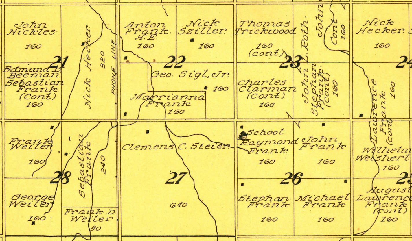
The other notable feature to be gleaned from the 1914 atlas is the ways families settled in close proximity. A segment of the 1914 atlas shows the Frank and Weiler families settling on adjacent parcels; indeed, the Frank family settled throughout the area pictured in this segment.
It also seems that farmsteads were typically located near streams and roads. Variations from this pattern likely relates to the topography. The area around Schefield consists of largely treeless, slightly rolling prairie. Certainly one factor that led settlers to construct permanent buildings was directly tied to the natural world, since the winters in the area are extreme.
As can be observed generally in the region, older farms rarely, if ever, are situated at the tops of hills where they would be subject to brutal winter gales; instead, they typically lie in relatively protected valleys or against the slopes of northern hills.
By 1914 the area appears to have been fully settled, but permanent settlement did not occur immediately. In fact, the earlier settlers in the region likely occupied temporary structures. Carvell describes these kinds of makeshift arrangements:
People arrived [and] they had no shelter at all. Sometimes they actually dug a hole in the ground, lived in a hole, or turned a wagon upside down and lived under the wagon…Imagine trying to live in a North Dakota winter under an overturned wagon!…They were pretty desperate to get into a structure…[so] they used the ingredients at hand, rock and mud, and they wanted to build it fast.
More common were sod dugouts, which made use of the sturdy prairie sod. Sod houses themselves were not meant to last, but they lasted long enough such that homesteaders could build more sturdy structures. Some pioneers even lived in outbuildings before they built houses. Geneva Steier recalled her husband’s ancestors living in the summer kitchen while they built their residence on their 640 acre parcel.[2]
The earliest permanent architecture to survive in the region strongly suggests the resourcefulness of the immigrants as they sought to make their way in a new land. With timber being scarce on the prairie and towns with lumber merchants being widely distant, farmers built with what they had, which was often rock. Wood for roof framing and stock trim seems to have been purchased locally (most likely in Dickinson or New England), but given the ready availability of stone in the fields, it served as the predominant building material for first period houses and outbuildings, particularly smokehouses, summer kitchens, and barns.
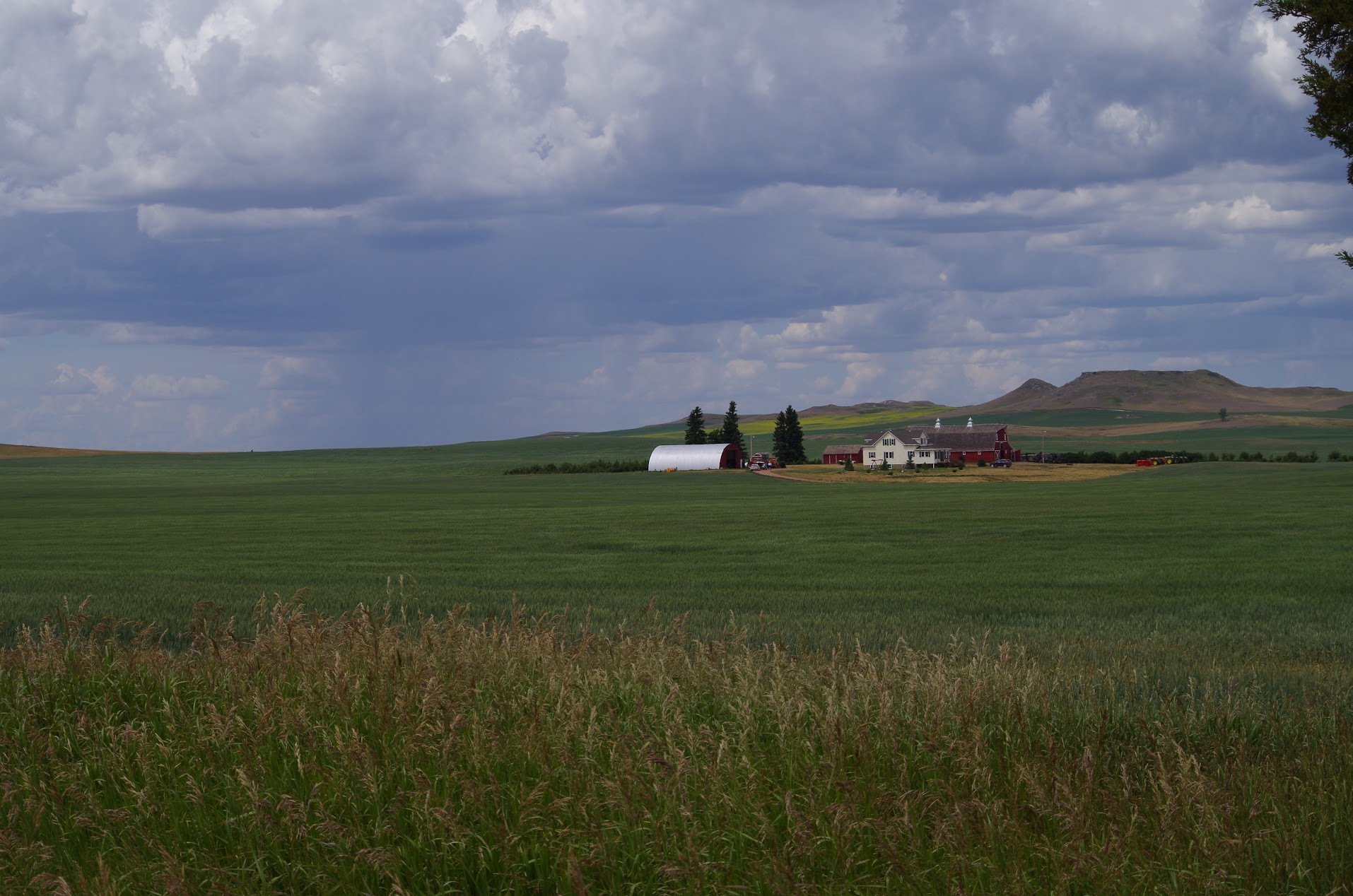
While building was part of settling the prairie, it also involved creating a sustainable setting for agriculture and farm life to flourish that extended beyond the walls of farm structures themselves. Settlers had to create farmland, which meant plowing the prairie and removing the rock which they used to build. The very act of plowing the sod prompted dust storms, which led to further changes to the natural world, most notably the planting of trees to protect the farmstead. The most pronounced organized efforts in this were done as part of the shelterbelt program (1934) of the New Deal, but there were likely earlier and certainly later “windbreaks” planted to protect the farmsteads and their occupants from the harsh prairie winds. The evidence of shelterbelts is starkly evident on the landscape today; the resultant landscape is one where undulating prairie is intermittently dotted with clusters of trees signaling widely dispersed farmsteads.
Farmstead Patterns & Features
As workplaces, farms evolve over time, and thus trying to gauge patterns of layout of first- and second-generation farms is challenging. One can estimate dates of construction of standing buildings or use historic photographs to attempt to map what a scheme might be, but given the fact farms have to (and do) change, it is difficult to reconstruct farmstead layout patterns with much precision. Yet taken collectively our study of farmsteads in the vicinity of Schefield reveal some distinct patterns, as well as raise questions about a larger regional pattern and whether it relates in any way to “old world” traditions.

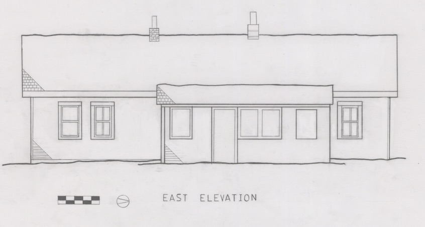
The Steier Farm (discussed individually in the next chapter) is perhaps one of the more intact farmsteads we studied, containing a first-period house (dating to around 1909), an early barn, and an assortment of early twentieth-century outbuildings. The arrangement of these buildings may be described as “clustered,” without a seeming geometric logic aside from one notable feature: a large, open farmyard at the center of the cluster of historic buildings. This pattern is repeated throughout the farms in the study area, including the A. Jirges and Raymond Frank Farms, where wide separation occurs between the houses and barns.
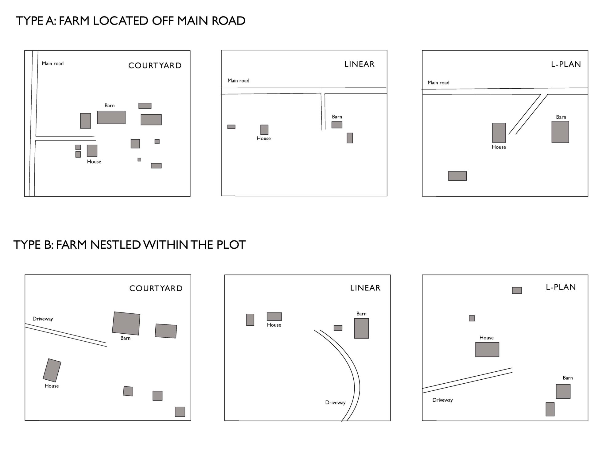
This observation led us to seek to explore layout patterns across farmsteads in the wider vicinity. Using aerial photographs, a visual analysis of farm patterns was made, which revealed several interesting results. Overall there appear to be two general patterns for siting of farmsteads: first, farms near the site of the road (this pattern is suggested by the Steier and Frank farmsteads); second, farms located further off the road near the center of the plot of land (see A. Jirges and Ehlis farms). Second, there were three distinct patterns in the ways the buildings are laid out within the farmstead: linear, courtyard and L-shaped. In all three cases, it is notable that there is considerable space allocated for a “farmyard,” whether in between the house and barn or nestled within an L or courtyard (U-shaped) arrangement. What this layout means remains a vexing question, especially considering that moving between the house and the barn would have been challenging during the long plains winter.
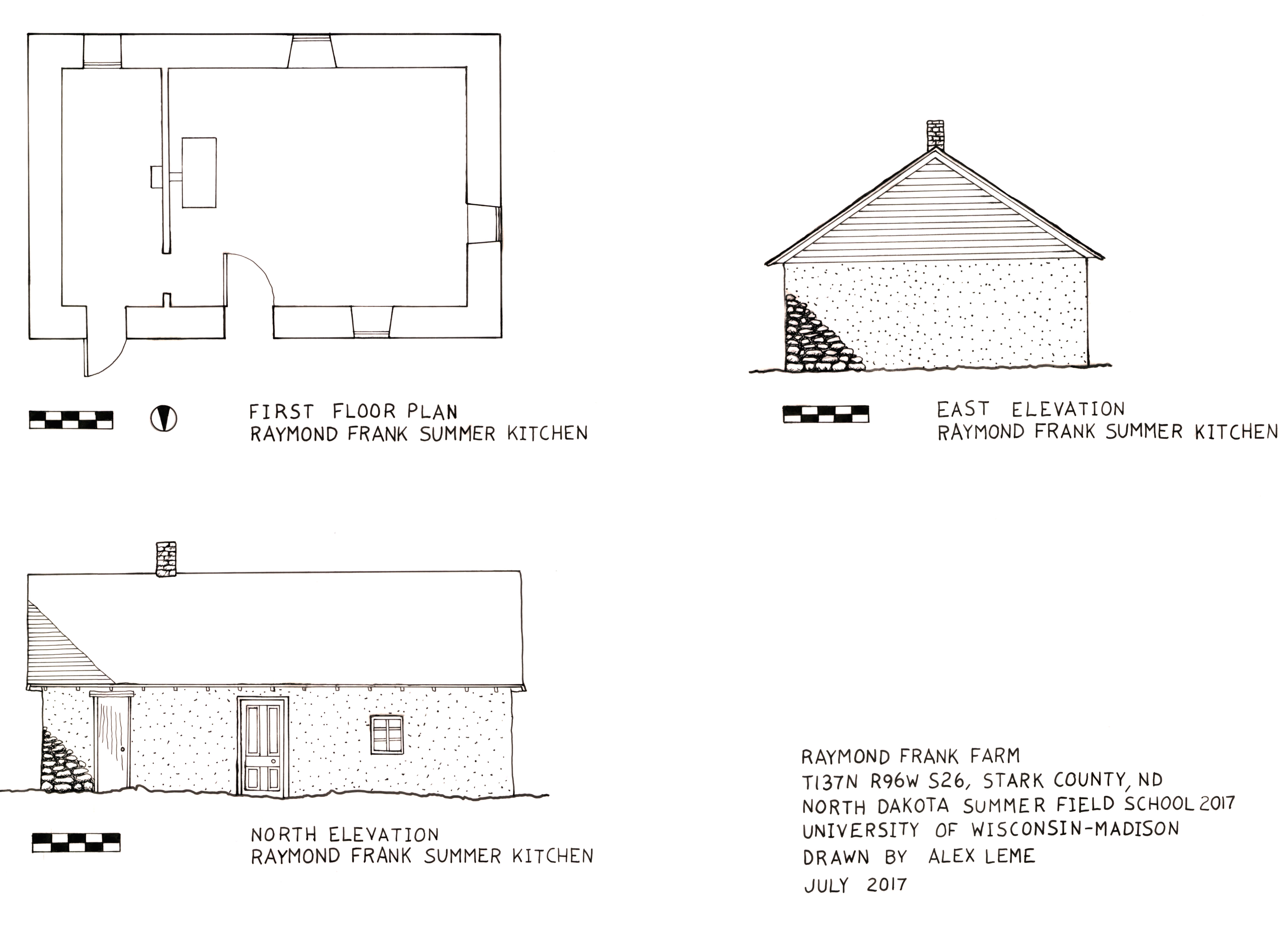
The types of outbuildings on these farmsteads are remarkably consistent, not surprising considering the general focus in the region on cash-crop wheat farming and self-sufficient raising of livestock. In addition to large multi-purpose barns, farms we studied had early smokehouses. Based on previous windshield surveys, smokehouses and summer kitchens were common in the region. The Raymond Frank Farm had a surviving summer kitchen of the sort that probably existed on most farms during the early twentieth century. Also found on farms were granaries and windmills as well as vehicle storage buildings.
Several farms in our study area had pronounced shelterbelts. Although the dates of these are difficult to determine (the only historic aerials date to the late 1950s and 1960s), they may date to the 1930s or at least are found in the same location as those from that period. Although in each case they surround the farmstead, they do show some variation. At the Raymond Frank Farm, the shelterbelt creates a U shape around the west, south, and east of the farm (the north side being somewhat protected by an upward slope). The Clemens Steier Farm, meanwhile, has windbreaks mainly on the east and west sides. The Frank Ehlis Farm has a wide shelterbelt wrapping around on the north and west sides in a L-shape, as if to protect the farmstead from the biting northwestern winds that frequent the Dakota prairie.
Further study of farms in the region would seek to answer some of these questions about patterns of types of buildings, farmstead layout and landscape organization. Climactic factors played a clear role in terms of the placement of shelterbelts, but what role the harsh winter climate played in the layout of farm buildings is less certain. Indeed, the large farmyard separating house and barn seems counterintuitive. Further questions arise about the kinds of agriculture practiced, how that changed over time, and how that affected the organization of the farms. Were earlier outbuildings replaced as crops changed (such as the move to rapeseed)? When did the shift from horses to mechanized vehicles take place and how did that impact farm life? Where were farm animals housed (no evidence of fencing existed on the farms we studied)? Behind many of these questions lie others about ethnicity and regional identity, which are further informed by looking at features of individual buildings themselves.
Signs of Ethnic and Regional Identity in Folk Farm Buildings
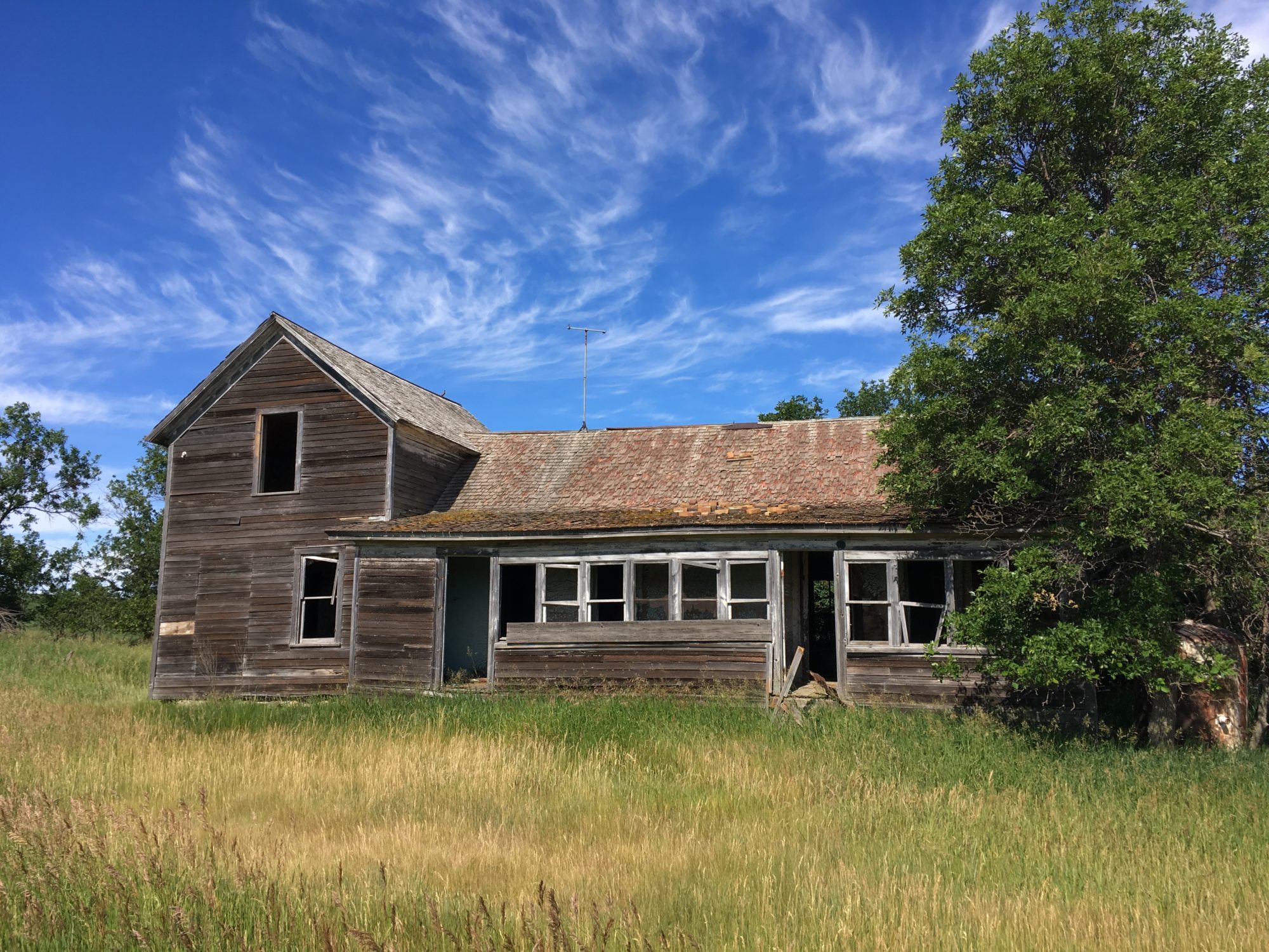
A sizable number of early twentieth-century buildings survive on these farmsteads, particularly farmhouses and first period barns. Most of these are built of masonry, although several are of wood frame construction. Documentary and oral historical evidence associate these early buildings with Germans from Russia, prompting questions about if and how this identity was manifest in these buildings. Such questions were at the forefront of our field investigations as we examined forms of the buildings, stylistic features, and methods of construction.
Five of the seven farms we examined had houses dating to the first quarter of the twentieth century. Of these five, three of the houses were rock, which is one of the forms of construction associated with Germans from Russia in the Great Plains, while the other two were built of wood frame.[3] While tempting to call all of these first period houses, the fact that the three stone structures are quite well built and the frame structures rather sizable suggests these were likely the second (or even third) dwellings built on these farmsteads. It is hard to confirm this, as sod structures, often the first to be built on the farms, have not survived.
The three masonry houses are all built of rough uncoursed fieldstone, likely gathered on site in fields surrounding the farmsteads. The stone was likely brought to the homesite using a “stoneboat”
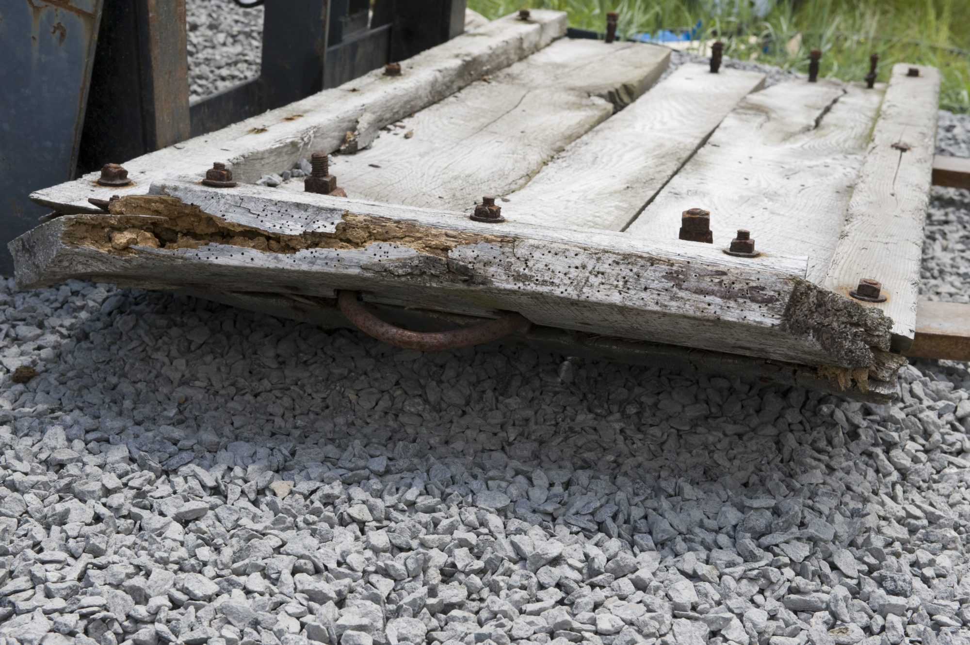
pulled by a horse or mule. This method of construction would not have been unfamiliar to the German-Russian pioneers; wood was not abundant on the Russian steppe, so several generations of German-Russians had learned stone building techniques. All of the stone houses were either clad with clay or plaster (or evidence existed they were clad with plaster at some point).

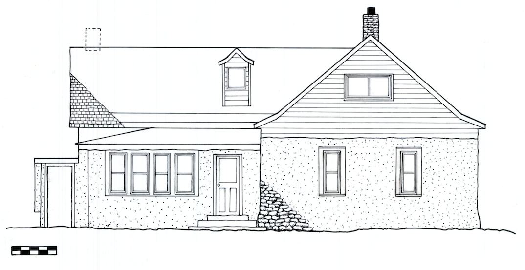
Masonry was also the building method of choice for early twentieth-century outbuildings, including the large multi-purpose barns found on five of the properties. These structures had masonry first floors, with the walls covered with clay or plaster to smooth their appearance. The loft stories were frame, often with gambrel roofs, though gabled and round forms are also seen in the project area. In the case of the barn on the Clemens Steier Farm, the original roof was a gambrel roof; but when fire destroyed the barn in 1959, the stone walls were lowered and the structure was capped with a round roof.[4] Smokehouses on the Clemens Steier and A. Jirges Farms and the summer kitchen on the Raymond Frank Farm also exhibit similar forms of masonry construction.
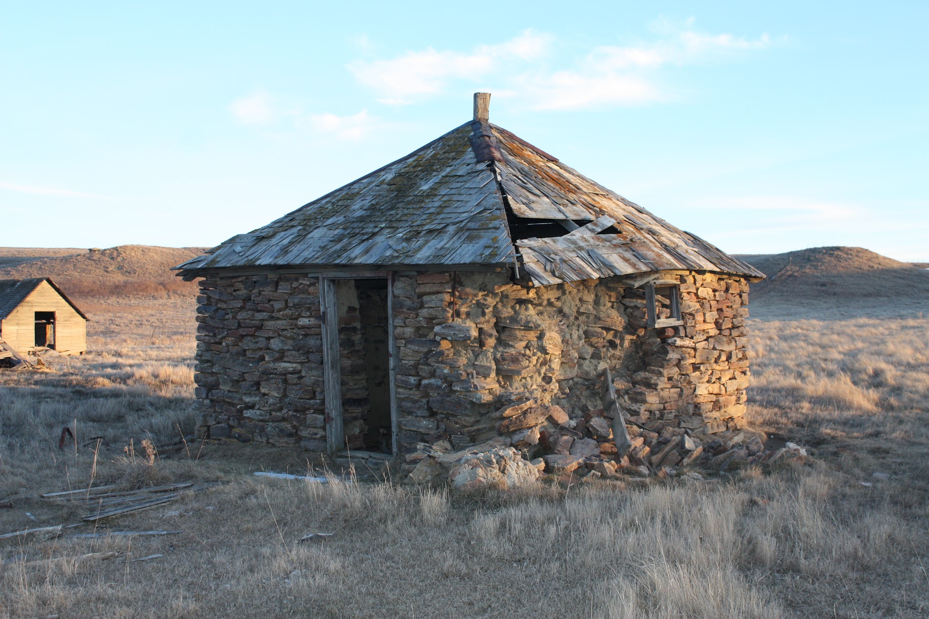
Typically these were not finished to the same degree as the houses or barns; the rock smokehouse on the A. Jirges farm appears to have never been plastered.
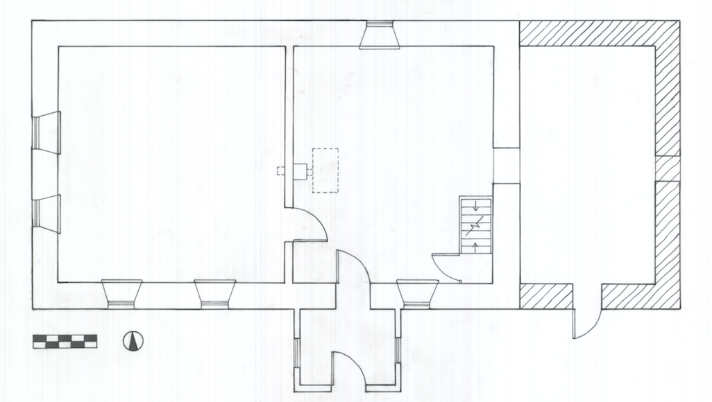
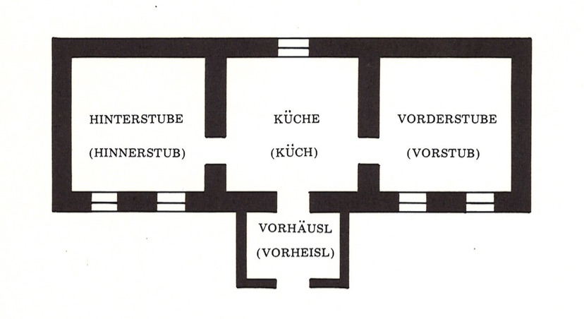
Observable patterns also appear in the form and appearance of the vernacular buildings. Three of the houses – on the Raymond Frank, Frank Ehlis, and Frank D. Weiler Farms – have one-room, one-story linear floor plans, a form is loosely associated in local imagination with a type popular among Germans from Russia. The floor plan of the house on the Raymond Frank Farm shows the closest association with the traditional form as discussed by William Sherman in which “an elongated rectangle one room deep…divided somewhat equally into three parts with the entrance and kitchen in the middle and the parents’ room (Vorderstube) facing the street and the childrens’ room (Hinterstube) on the opposite side of the house.”[5] Off the kitchen was the entrance vestibule, known as a Vorhausl, a telltale feature of German-Russian houses in the region (as well as in Russia). The Raymond Frank House is also oriented on a strict east-west axis, another hallmark (according to Sherman) of this house form. And as typical, there was only one window in the north elevation to light the kitchen/primary living area.
For all that the house on the Raymond Frank Farm would seem to share with Sherman’s “typical” Germans from Russia house form, it also exhibits notable differences, as do the other linear house forms in our study area. The easternmost room of the Frank House does not appear to have been a childrens’ sleeping area, but rather was likely used for coal storage, as a barn, or perhaps both.[6] The other houses displaying linear massing don’t appear to be organized the same way. The Frank Ehlis House has three rooms (with a fourth added on the north end), but the front ell is not a traditional Vorhausl but a kitchen (and was likely itself an addition). The periodization of this house, moreover, is not clear, as different parts were built at different times. Finally, the house on the Frank D. Weiler Farm also exhibits a linear scheme, but it is of frame construction– not rock – and also has shed-roofed additions off the long sides, obscuring to some extent its linear massing.
While the sample size here is too small from which to draw widespread conclusions about regional building forms or construction techniques, enough pattern exists to point towards what a more complete study might yield. Clearly the relatively sophisticated stone masonry suggests the need to further study the network of people who may have been involved in rock construction, as the techniques do not appear to have been remotely makeshift (and the buildings are likely not self-built). Moreover, the forms of the houses and barns look patterned enough to beg the question about the relationship of these forms to the houses and barns in Russia as well as the broader region. Finally, enough variation exists within the buildings from the first quarter of the twentieth century itself to warrant further study, as it suggests that even within the first twenty years of permanent settlement, older ways made way for the new; was this a function of the prairie environment, acculturation, hybridity or a combination of factors?
Succeeding on the North Dakota Prairie
The surviving historic buildings in the Schefield area materialize the history of their prior owners and occupants. Yet to mark them as “German-Russian” in any strict sense minimizes the rich stories they have to tell about the individuals who occupied them and the region as a whole. As much as patterns exist in the study area, there is enough variation to demand we look further and think more deeply about what that variation represents. While one could say it is simply showing ethnic ways giving way to American ones, the story instead seems to be one about “making it” over successive generations.
Taken collectively, these farms narrate stories of success – of success of individual farmers over the climate, of farmers over time, and of the community as a whole. The move to more permanent life on the plains, exemplified in masonry construction, particularly of the sizable multi-function barns, in itself is a marker of success over the sod dugouts that the earliest pioneers likely occupied. Improvements to the farms over time – the modern structures, especially vehicle storage sheds marking the rise of mechanization as well as other improvements to the farm landscape – also support this story.
The shelterbelts, which on first glance may appear to be nothing other than ornament, actually also express a kind of success. The conquering of the prairie was not complete without the plow; but once the farmers plowed the grasses and cultivated the soil, they faced the wrath of the prairie wind, which blew the dust and wrecked havoc on everyday farm life (and even farming). The shelterbelts mounted a challenge to the elements, and as such, represent a sign of triumph of the settlers over the natural world.
Improvements over time on these farms also speak of the success of individuals and individual families. The house on the Clemens Steier Farm is a telling example of this. Clemens Steier was a “first generation” German-Russian immigrant; his naturalization papers were filed in 1898. After he married in 1901, he moved into a small stone house on his farm about fifteen miles south of Dickinson – likely old world style – where he lived until 1909. At that point Clemens bought an additional full section of land on which he would erect the current house. This house, as his second, was evidence he had “made it” after a decade on the prairie. Rather than a single-pile linear house (such as the Frank House), his house looked modern, like the urban houses of nearby Dickinson. And yet, unlike the examples built with sawn lumber from the Sears and Roebuck catalogs, Steier’s house, while visually similar to those examples, was built using masonry techniques more akin to its German-Russian predecessors. The house, then, is a blend – of ethnic construction melding with modern American form and style.
The same story might be said as we look across farmsteads, from the earliest house in our study area – that on the Raymond Frank Farm – to the latest one on the A. Jirges farm. The house on the Frank Farm is closest to an “old world” form, with its horizontal east-west layout and stone construction, whereas the house on the A. Jirges farm is a classic vernacular form of the American middle west, the “upright and wing,” found throughout rural America from the later nineteenth into the early twentieth centuries.
If we look at what happened from the first decade of the twentieth century – when the Frank house was built – until the third decade, we see a regional story of acculturation, or accommodation, to regional (as opposed to ethnic) ways. While it would be east to say it was the transition of German-Russian to American, it is likely something that happened for all ethnic groups on the prairie across several generations.
As we move across time, then, we see a rapid shift from old world ways to something more distinctly rural American. It was not sudden, of course; the Frank family continued to live in their original farmstead for many decades, just as the Steiers have modified their farmhouse until the present day. And we know of other German-Russian cultural survivals in language and food ways. What material culture evidence tells us that is new has to do with signaling the complexity of this process. As farmers became accustomed to life on the plains and accumulated wealth, they invested in modern American ways – be it a new house, a new kind of barn, or a shelter belt. These visual and material markers spoke of a kind of “success” to themselves as well as their neighbors, in some cases a mere generation after their ancestors first came to the prairie.
And such success is also tied to the former community of Schefield and the church of St. Pius, the social and cultural center for many of these farmers. This was, after all, where many of these families worshipped. George Ehlis went to school at St. Pius in Schefield. Others went to the Weiler Store, while others socialized at the Verein Hall. Schefield was the ultimate sign of success in this landscape – a symbol that the transplanted culture of the original German-Russian settlers had become permanent on the prairie.
And yet the extent of those who worshipped at St. Pius itself merits future study. As does whether or not the German-Hungarians, who worshipped at St. Elizabeth’s in Lefor, followed a similar trajectory as their German-Russian counterparts in marking their success in buildings and their farmsteads. As we drove the roads en route to our study area, we saw countless remains of other farm buildings, whose stories remain to be told through investigation of stone and mortar and through unraveling the stories of descendants of the original homesteaders.
- U.S. Census, Schedule of Population, 1900 and 1910. ↵
- Geneva Steier interview with Michelle Prestholt, June 27, 2017. ↵
- Michael Koop, “German-Russians,” in America’s Architectural Roots: Ethnic Groups that Built America, ed. Dell Upton (Washington, DC: Preservation Press, 1986), 130-35. ↵
- Betty Gardner and Eleanor Olson, New England Centennial, 1886-1986: Century of Change (Bismarck: NDSU, 1986), 548. ↵
- William Sherman, “Prairie Architecture of the Russian German Settlements,” in Russian-German Settlements in the United States, ed. Richard Sallett (Fargo: North Dakota Institute for Regional Studies, 1975), 187. ↵
- The current owner, Jeff Frank, insists it was coal storage as long as he and his parents remember, although there is some evidence this may have been used for animals with remnants of a loft. ↵